Lamoille River Watershed Initiative

Organizations involved in the Lamoille Watershed Basin planning process recognized the need for watershed-wide implementation efforts in 2004. Lamoille County Conservation District took the lead by implementing the Lamoille Watershed Initiative which is dedicated to serving all parts of the watershed within and beyond the boundaries of Lamoille County. LCCD works to improve the health and vitality of the Lamoille River Watershed completing projects as below.

The Lamoille River Basin Plan provides the foundation for LCCDs Strategic Plan. The Vermont Department of Environmental Conservation’s (DEC) Basin Planning Process for the Lamoille River drainage area was completed in 2009.  Many of the action items were implemented by LCCD throughout the years.  The underlying objective of the Vermont Basin Planning Process is to protect the high quality surface waters of the basin and to restore those waters that do not meet the Vermont Water Quality Standards. DEC works in a collaborative with other state, federal, non-profit and volunteer organizations as well as local residents for input, funding, technical assistance, and public education for various water quality improvement projects identified through the watershed planning process. DEC is a major supporter for organizations like LCCD that plan, develop, and implement river corridor protection and restoration projects. In December, 2016, the new updated Lamoille River Tactical Basin Plan was adopted and is now available for use.

Lake Watershed Action Plans

Through Ecosystem Restoration Program grants provided by the Vermont Department of Environmental Conservation in 2017 and 2019, the Lamoille County Conservation District (LCCD) conducted a full watershed assessment of the Lake Elmore and Lake Eden watersheds.   

LCCD contracted Fitzgerald Environmental Associates LCC and partnered with Lamoille County Planning Commission, VT Department of Environmental Conservation, VT Department of Fish and Wildlife, the Vt Department of Parks and Recreation, Town of Eden and Elmore, Lake Elmore Association and Lake Eden Association,  Lake Elmore and Lake Eden shoreline landowners and Vermont Youth Conservation Corp (VYCC) to complete this study.

Both lakes are pristine lakes  but has been showing nutrient (i.e. Phosphorus) and sediment loading stresses due to development patterns surrounding the lake. The studies assessed what locations these stressors were most impactful by conduction road erosion inventories, stream walks and shoreline assessments. LCCD worked closely with the town and lake association to identify known issues as well. Approximatly 50 possible projects were identified and 10 of these that ranked highest were brought to 30% design.

As part of this assessment LCCD and The VT Agency of Natural Resources also made inroads introducing the Lake Wise program to local shoreline owners. Lake Wise is a program that helps these land owners implement shoreline Best Management Practices (BMPs) for stormwater management, storm resiliency and improved wildlife habitat. Shoreline owners who score particularly well with their land stewardship will receive a certification and a sign that they can proudly display on their shoreline for their neighbors to see. While the assessment was in progress approximatly 16 BMPs were installed around the lakes with the help of the VYCC and volunteers.

LCCD intends to implement best management strategies to mitigate sediment and nutrient loading   at these 10 sites over the next year combined with continued monitoring of water quality. It is important to note that this project as well as all other stormwater, watershed or natural resource conservation projects are also focused on reducing the overall Total Maximum Daily Loads of Phosphorus in the Lake Champlain Basin as spelled out in the State’s Clean Water Initiative and the new goals of the Clean Water Act 76.  

For more information, please contact the LCCD director at [email protected] or 802-521-3004.             

The Lake Elmore Watershed Action Plan

Lake_Elmore_Watershed_Action_Plan Appendixes listed in plan can be requested through contact listed above. 

Mt Norris Reservation 30% Design

Concept_Scout_Camp_DRAFT (1)Your content goes here. Edit or remove this text inline or in the module Content settings. You can also style every aspect of this content in the module Design settings and even apply custom CSS to this text in the module Advanced settings.

Lamoille River Watershed Education and Outreach Projects

  • Raising public awareness through education and engagement and supporting local watershed-improvement actions and projects;
  • Leading, coordinating partners, organizations, and projects that cross jurisdictional boundaries for landowners, farmers, and foresters;
  • Providing Service-Learning Opportunities for all ages and educational programs aligned with VT State Frameworks.

Created by LCCD for educators, farmers, and citizens to provide information on Lamoille River’s cultural and natural history, resource concerns, and lesson plans on Phosphorus, Vermont Accepted Agricultural Practices, and Riparian Buffers. Power Point Presentations and Educational Kits are also available as a complement to the guide. The most local guide to the history of and current concerns of the Lamoille Watershed. The Lamoille River Watershed Agriculture & River Resource Guide was made possible with support from the Vermont Agency of Agriculture and the Morrisville Rotary Club.

Lower Lamoille River History Booklet

This small but useful publication gives an excellent history of the lower Lamoille River with references to the Peterson Dam. Used with permission and written by Jeff Fellinger for the Vermont Natural Resources Council, 2000.

Lamoille River Watershed Educational Kits

Watershed Educational Kits are available for teachers to use in the classroom or field setting. These include a Lamoille River Map Kit, Macroinvertebrate Field Study Kit, Macroinvertebrate Lab Kit, and Water Chemistry Kits. There is a small fee for shipping and deposit required for loaning materials. Check out the LCCD Conservation Education Programs Brochure for more information.

Lamoille River Map Resources

VT ANR Natural Resources Atlas
Old Maps of New England – Beer’s Atlases
Lamoille Watershed Association Map
The Lamoille River Subbasin Map
Lamoille County Planning Commission Map

Lamoille River Photo Gallery

Photos of the Lamoille River from the headwaters to mid-watershed. May be used for educational purposes and credited to Kimberly Jensen.

Lamoille Watershed Water Quality Monitoring and Exchange Project

LCCD visited participating schools in the Lamoille Watershed to introduce a collaborative Vermont EPSCoR Stream Project being completed by colleges in the watershed. Middle and high school students were introduced to the Stream Project and followed similar protocols in gathering data in the field at sample sites where college students also gathered data. In some cases, representatives from colleges were available to guide students in the data collecting. Sampling consisted of a macroinvertebrate analysis, chemistry test, and riparian buffer observation. Participating Colleges – University of Vermont, Johnson State College, Sterling College, St. Michael’s College. Participating Schools – Craftsbury Academy, Lamoille Union Middle & High Schools, and Peoples Academy Middle School.

Looking for more data?

Check out data from the Vermont EPSCoR Streams Project. The VT EPSCoR (Experimental Program to Stimulate Competitive Research) Streams Project is dedicated to collecting and sharing data from streams of the Lake Champlain basin and beyond. VT EPSCoR works with students, teachers, undergraduates and faculty from around the state in this effort. The data gathered serves the needs to a Complex Systems Modeling Group as well as many state/local agencies in finding solutions to the pollution issues in our waterways. Explore this site to learn more!

In 2015, LCCD assisted Lamoille County Planning Commission to create an online interactive “Story Map” to illustrate and explain river processes and how human activities impact the equilibrium of rivers and streams. Perhaps more importantly, the Story Map highlights the great restoration work that is being accomplished by many organizations and partnerships throughout the Lamoille Watershed.

Lamoille River Paddlers Trail

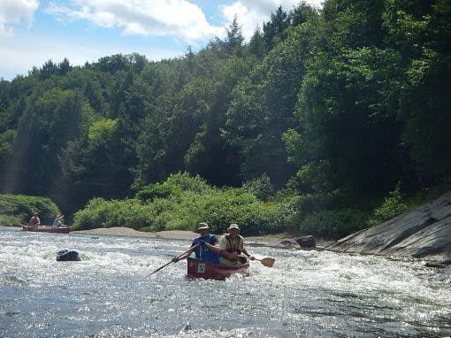
The Lamoille River Paddlers’ Trail (LRPT) is an emerging, community effort to develop new opportunities for paddling and fishing along the Lamoille River. The emerging organization’s mission is to complete a network of well-maintained river access points, primitive campsites, and portage trails from the river’s headwaters west to Lake Champlain. LRPT recognizes the region’s rich ecology and productive working landscape and seeks to facilitate a recreational use for the river compatible with the river valley’s natural and social character. Their website contains a comprehensive series of maps for paddling and exploring the Lamoille River. LCCD is a member of the LRPT Steering Committee.